The appearance of a U.S. Navy MQ-4C Triton over the Caribbean Sea on 8 January 2026 offered a rare, unfiltered glimpse into how modern maritime surveillance is actually conducted in practice. Unlike officially released imagery or carefully worded press statements, this episode unfolded in near real time through open-source flight-tracking data, briefly exposing the outline of a mission designed for endurance, persistence, and quiet observation rather than spectacle.
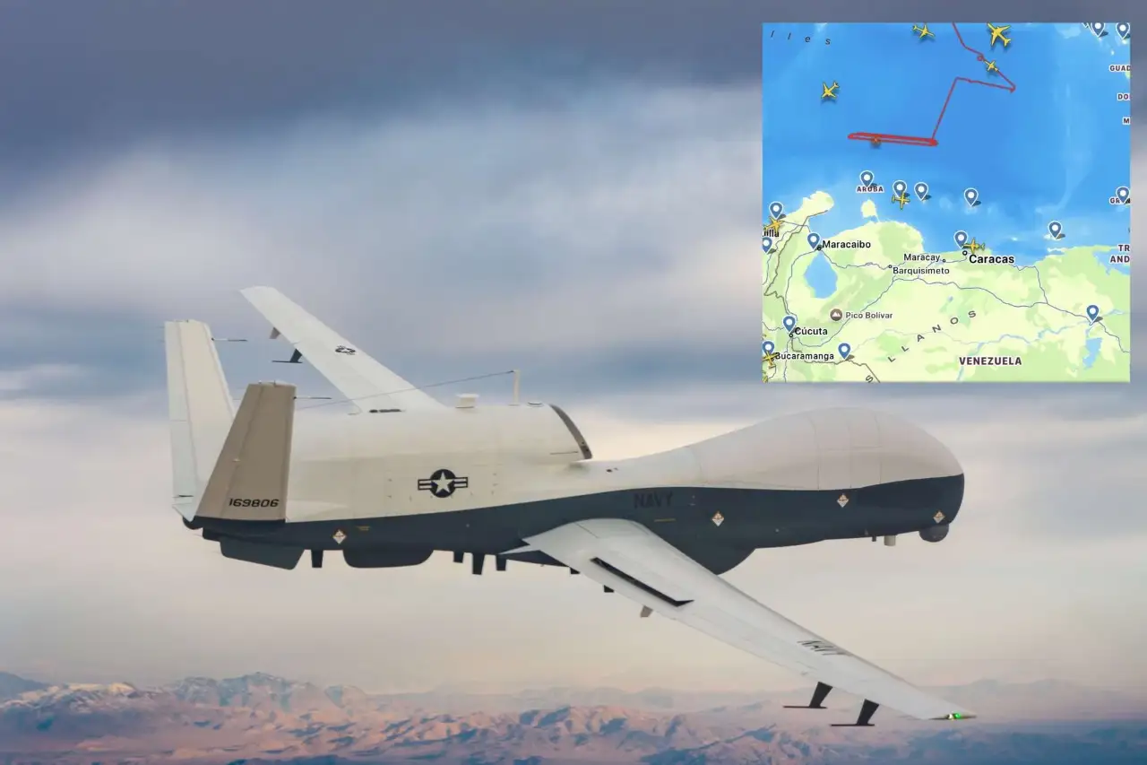
Flight-tracking data showed the unmanned aircraft departing the vicinity of Naval Station Mayport, Florida, before turning south and settling into a high-altitude profile over international waters in the Caribbean. The Triton remained visible long enough for observers to confirm its identity, callsign, and general operating pattern before it faded beyond the reach of civilian tracking networks. Even this partial visibility was enough to underline how central long-endurance unmanned aircraft have become to U.S. maritime awareness far beyond coastal approaches.
At the center of this sortie was MQ-4C Triton BuNo 169659, flying under the callsign BLKCAT6. Once on station, the aircraft maintained an altitude of roughly 47,000 feet, a sweet spot that maximizes radar horizon and sensor coverage while keeping the platform well above most commercial traffic. The drone traced a repeated east–west pattern north of Venezuela, a classic reconnaissance geometry optimized for systematic coverage rather than rapid transit.
Open-Source Tracking Reveals a Persistent Maritime Mission
Publicly accessible data from Flightradar24 briefly captured the Triton’s outbound leg and the initial phase of its on-station operations. The track showed a deliberate transition from transit flight into a structured patrol pattern, signaling the start of an intelligence, surveillance, and reconnaissance mission rather than a simple relocation or training sortie. The visible portion of the flight alone stretched across nine to ten hours, highlighting the aircraft’s ability to loiter for extended periods without the constraints imposed on crewed patrol aircraft.
What open-source data can show is movement, altitude, and time. What it cannot show is payload configuration, sensor tasking, or specific targets of interest. That distinction matters. While the aircraft’s proximity to the Venezuelan coastline drew attention, the available data only confirm that BLKCAT6 operated in international airspace, executing a pattern consistent with wide-area maritime surveillance. Any deeper interpretation of mission intent remains speculative without official confirmation.
The Strategic Context of the Caribbean Patrol Area
The waters north of Venezuela occupy a complicated strategic space. The Caribbean is a dense maritime environment where commercial shipping lanes, energy transport routes, and regional naval activity overlap. In recent years, the region has also drawn heightened attention from U.S. and allied planners due to concerns surrounding illicit oil movements, sanctions evasion, and opaque shipping practices involving vessels with obscured ownership or irregular routing behavior.
Within that environment, persistent surveillance matters more than short bursts of observation. A single pass by a crewed patrol aircraft can provide a snapshot. A platform like Triton, by contrast, can build a moving picture over time, tracking how vessels behave across hours rather than minutes. That ability to observe patterns instead of isolated positions is often the difference between routine traffic and activity that merits closer scrutiny.
MQ-4C Triton and the Architecture of Endurance
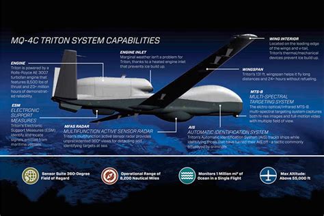
The MQ-4C Triton is purpose-built for this kind of mission. Designed as a high-altitude, long-endurance unmanned aircraft optimized for maritime operations, Triton can remain airborne for up to 30 hours under favorable conditions. Its airframe incorporates structural reinforcement, de-icing systems, and corrosion-resistant features tailored for sustained operations over open ocean, where weather and salt exposure rapidly degrade less specialized platforms.
Unlike smaller tactical drones, Triton operates at altitudes comparable to strategic reconnaissance aircraft, giving its sensors a commanding view of vast sea areas. At these heights, the aircraft’s radar horizon expands dramatically, allowing it to detect and maintain tracks on surface contacts spread across hundreds of nautical miles. That wide-area coverage is central to its role in supporting maritime domain awareness rather than narrow, target-specific collection.
Sensor Design Focused on Maritime Reality
Triton’s sensor suite is engineered around the realities of ocean surveillance. Its primary maritime radar is optimized for detecting, classifying, and tracking surface vessels across cluttered sea states and dense shipping environments. This includes the ability to revisit contacts repeatedly, refine tracks over time, and flag anomalous behavior such as sudden course changes, unexplained loitering, or rendezvous activity at sea.
In practical terms, this means Triton can quietly maintain custody of vessels that would otherwise blend into commercial traffic. Ships that disable or manipulate identification systems, alter routes without clear commercial logic, or operate in proximity to known transfer areas stand out more clearly when observed continuously rather than intermittently. The east–west “lawnmower” pattern flown by BLKCAT6 on 8 January is particularly well suited to this kind of systematic coverage.
High Altitude as a Force Multiplier
Operating near 47,000 feet is not just a matter of endurance; it is a force multiplier. At that altitude, Triton can survey larger areas with fewer orbits, maintain line-of-sight communications over longer distances, and remain largely unaffected by the congested airspace closer to the surface. It also allows the aircraft to operate above most weather systems, reducing the need to deviate around storms that can interrupt lower-altitude patrols.
This altitude advantage also contributes to operational discretion. While the Triton was briefly visible on civilian trackers, its actual sensor operations and data links remain opaque to outside observers. From a strategic perspective, that combination of partial visibility and deep opacity is often intentional, signaling presence without revealing specifics.
No Official Confirmation, Only Observable Facts
As of this writing, there has been no official U.S. Navy statement confirming the purpose of the 8 January Triton mission. No press release has clarified tasking, objectives, or outcomes. That silence is not unusual. Long-endurance ISR sorties are frequently routine elements of ongoing monitoring efforts rather than discrete events intended for public messaging.
What can be stated with confidence is limited to observable facts. MQ-4C Triton BuNo 169659 launched from Florida, flew south into the Caribbean, established a high-altitude patrol pattern north of Venezuela, and remained on station for an extended period before disappearing from civilian tracking coverage. These details align precisely with Triton’s designed mission profile.
Maritime Domain Awareness in Practice
The 8 January sortie illustrates how maritime domain awareness is actually maintained in regions of interest. Rather than dramatic shows of force, it relies on patient observation, data fusion, and persistence. A Triton orbit does not act alone; it feeds information into a broader network that may include crewed patrol aircraft, naval vessels, satellites, and allied sensors. Each contributes a piece to a continuously updated operational picture.
In this framework, Triton’s role is often to cue rather than to act. By identifying patterns and anomalies, it allows decision-makers to allocate more visible assets efficiently. A tanker that behaves normally passes unnoticed. One that deviates from expected behavior can trigger closer inspection elsewhere, sometimes days or weeks later.
Why the Caribbean Matters to Long-Endurance ISR
The Caribbean remains a region where geography, commerce, and geopolitics intersect sharply. Its sea lanes connect the Atlantic to the Panama Canal, support energy flows, and border states with complex political relationships to Washington. Persistent surveillance in this environment is less about confrontation and more about continuity: ensuring that developments at sea do not go unnoticed simply because no one was watching at the right moment.
Triton’s endurance makes it uniquely suited to this role. While crewed aircraft rotate crews and contend with fatigue, an unmanned platform can hold station through an entire operational window, watching traffic patterns evolve across a full day-night cycle. That continuity often reveals behaviors invisible in shorter sorties.
A Quiet Indicator of Evolving Naval Surveillance
The brief appearance of BLKCAT6 on civilian tracking platforms was not dramatic, but it was revealing. It showed how unmanned systems are now woven into the fabric of everyday naval operations, performing missions once reserved for crewed aircraft, and doing so with greater persistence and lower operational strain.
As maritime surveillance increasingly emphasizes data, patterns, and long-term observation, platforms like the MQ-4C Triton are likely to play an even larger role. The 8 January patrol north of Venezuela was not an anomaly; it was a snapshot of a new normal, where strategic awareness is built quietly, hour by hour, at 47,000 feet over open water.


