Landing an aircraft is often described as the defining test of a pilot’s skill. While modern airliners are equipped with sophisticated avionics, advanced autopilot systems, and precision navigation technology, there are still airports where technology alone cannot guarantee a safe arrival. In these locations, terrain, weather, runway limitations, and local procedures demand exceptional judgment and manual flying ability from the crew.
Commercial pilots routinely refer to takeoff and landing as the busiest moments in any flight. At low altitude, decisions must be made within seconds, and opportunities to recover from mistakes are limited. Aviation authorities around the world classify these stages as critical because they combine complex aircraft handling with rapidly changing environmental conditions.
Some airports amplify those challenges dramatically. Towering mountains block standard approaches, crosswinds shift unpredictably across the runway, and visual maneuvers replace straightforward instrument guidance. In several cases, pilots cannot simply rely on an Instrument Landing System and descend along a stable path. Instead, they must navigate using valleys, landmarks, or carefully choreographed turns that leave almost no margin for error.
The result is a handful of destinations that have earned legendary reputations throughout aviation. Flying into them requires specialized certification, simulator sessions, supervised operations, and years of accumulated experience. Many airlines restrict these routes to their most qualified crews, while regulators impose strict requirements before granting authorization.
Why Some Airports Are Far More Difficult Than Others
Not every difficult airport is defined by a short runway or dangerous weather. Often, it is the combination of multiple operational hazards that creates extraordinary complexity.
Several factors commonly contribute to technically demanding landings:
- High elevation, reducing engine performance and aerodynamic efficiency.
- Mountainous terrain, preventing conventional straight-in approaches.
- Strong and rapidly changing winds, particularly crosswinds and downdrafts.
- Short runways, leaving limited stopping distance.
- Visual-only procedures, requiring pilots to identify landmarks instead of relying entirely on instruments.
- Restricted go-around opportunities, where surrounding terrain prevents an aborted landing.
These characteristics transform routine arrivals into operations requiring extensive preparation and flawless execution.
Aspen-Pitkin County Airport: North America’s Mountain Flying Masterclass
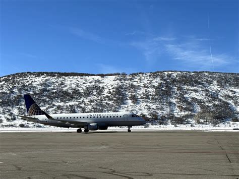
Nestled within Colorado’s Rocky Mountains, Aspen-Pitkin County Airport has become synonymous with demanding airline operations in the United States. Sitting approximately 7,820 feet above sea level, the airport combines significant elevation with steep surrounding terrain that reaches roughly 14,000 feet.
Unlike conventional airports where arrivals and departures may use the same runway direction depending on wind conditions, Aspen follows a highly specialized operational concept. Aircraft generally land on Runway 15 while departures use Runway 33 because nearby mountains severely restrict alternative procedures.
Pilots operating here face continuously changing wind conditions as air currents interact with mountain ridges and valleys. Even relatively minor atmospheric changes can alter aircraft performance during the final approach.
The Federal Aviation Administration requires dedicated training for crews serving Aspen, reflecting the airport’s unique complexity. During busy periods, controllers may coordinate tightly sequenced opposite-direction movements using locally developed procedures that require precise timing and communication between pilots and air traffic control.
Visibility can deteriorate rapidly as weather systems move through the mountains, making specialized instrument procedures essential. Even then, terrain remains a constant consideration, forcing crews to maintain exceptional situational awareness until touchdown.
For many professional aviators, Aspen represents the most technically demanding scheduled commercial destination in North America.
London City Airport: A Steep Descent into the Heart of London

Few airports combine dense urban geography and precision flying quite like London City Airport. Located close to Canary Wharf and central London’s skyline, the airport operates within one of Europe’s busiest airspaces while offering a runway significantly shorter than those found at major international hubs.
Its defining feature is the remarkable 5.5-degree approach angle, almost double the standard three-degree glide path used at most commercial airports worldwide.
That steeper descent exists for a practical reason. Tall buildings surrounding the airport require arriving aircraft to descend more aggressively while remaining clear of urban obstacles before aligning with the runway.
This unusual profile demands aircraft specifically certified for steep approaches, while airlines and pilots must also obtain dedicated regulatory approval. The procedure alters cockpit workload considerably because descent rates become substantially higher than those encountered during ordinary airline operations.
Pilots making their first operational visit undergo carefully supervised familiarization flights that include approach practice and go-arounds under prescribed weather conditions.
The relatively short 1,508-meter runway further increases precision requirements. Excessive speed during touchdown can quickly consume valuable stopping distance, leaving little opportunity to compensate for errors.
Although surrounded by one of the world’s largest metropolitan areas, London City demonstrates that urban infrastructure can create aviation challenges every bit as demanding as rugged mountain terrain.
Madeira Airport: Atlantic Winds and a Spectacular Visual Turn
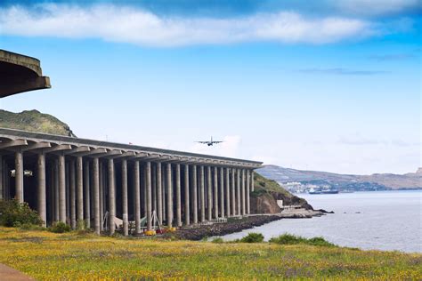
Cristiano Ronaldo International Airport on Portugal’s Madeira Island enjoys breathtaking scenery, yet that beauty conceals one of Europe’s most technically intricate approaches.
While arrivals to Runway 23 can follow relatively straightforward instrument guidance, Runway 05 presents a completely different challenge. Geography prevents a conventional straight-in Instrument Landing System approach, requiring pilots to execute a visual maneuver involving a dramatic 180-degree turn before lining up with the runway.
The transition from open ocean to final approach occurs within seconds, demanding continuous monitoring of altitude, airspeed, and alignment.
Adding to the complexity are powerful Atlantic crosswinds generated by nearby cliffs and changing weather patterns. Wind direction may fluctuate quickly enough to create unstable conditions that force diversions even when differences appear minor.
Portugal classifies Madeira as a Category C airport, reflecting the specialized expertise necessary for safe operations. Pilots complete simulator instruction and observe live flights before receiving authorization to command arrivals independently.
One remarkable engineering achievement also defines Madeira. The runway extension constructed above the coastline rests on hundreds of reinforced concrete pillars, effectively creating an elevated platform projecting beyond the island itself.
The combination of visual maneuvering, coastal winds, and surrounding terrain ensures that every landing remains an exercise in concentration from beginning to end.
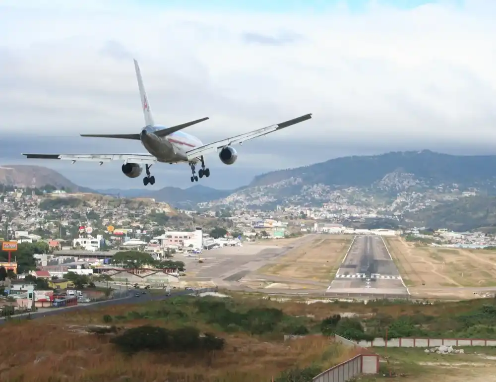
Tenzing-Hillary Airport in Lukla: The Tiny Runway Beneath Mount Everest
Few airports have captured the imagination of aviation enthusiasts like Tenzing-Hillary Airport in Lukla, Nepal. Serving as the principal gateway for trekkers heading toward Everest Base Camp, it is frequently cited among the world’s most intimidating places to land.
Its runway measures only about 527 meters, making it dramatically shorter than those used by conventional commercial aircraft. Compounding matters further, the strip features an uphill gradient approaching 12 percent, intentionally designed to assist deceleration after touchdown.
The airport’s location at more than 9,300 feet above sea level introduces additional aerodynamic complications. Reduced air density decreases both engine output and wing performance, requiring careful performance calculations before every operation.
Perhaps the most striking aspect of Lukla is the surrounding geography. One end of the runway terminates near steep mountainsides, while the opposite end falls away sharply into a deep valley.
A go-around after committing to the final stages of landing is often not realistically available because of terrain limitations. Consequently, pilots must stabilize the approach well before crossing the threshold.
Navigation infrastructure remains intentionally simple. There is no Instrument Landing System or radar guidance, leaving crews dependent on visual references and favorable weather conditions.
Nepal’s aviation authority therefore imposes rigorous qualification standards, including substantial short takeoff and landing experience along with supervised operations before pilots may fly independently into Lukla.
Even among seasoned mountain aviators, respect for this airport remains universal.
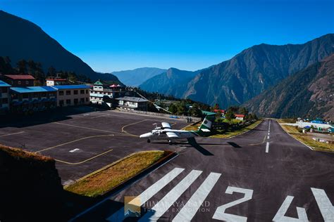
Paro International Airport: Bhutan’s Himalayan Flying Challenge
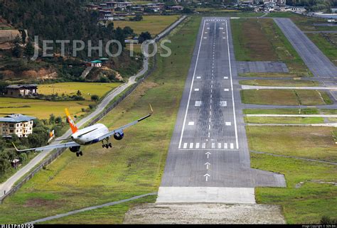
Paro International Airport consistently appears at the top of discussions regarding the world’s most technically demanding airline destinations.
Positioned approximately 7,332 feet above sea level within a narrow Himalayan valley, the airport is enclosed by peaks rising to nearly 18,000 feet. These mountains eliminate the possibility of straightforward instrument arrivals used elsewhere across the globe.
Instead, pilots manually navigate winding valleys while visually identifying predetermined landmarks before reaching the runway environment.
Unlike many major airports where crews may establish visual contact from more than ten nautical miles away, Paro’s runway often becomes visible only during the final one or two nautical miles of flight.
This compressed timeline leaves almost no opportunity to correct navigation errors.
The airport also lacks radar-based approach guidance, meaning pilots depend heavily on experience, disciplined procedures, and intimate familiarity with the surrounding terrain.
Strong anabatic and katabatic winds generated by mountain heating and cooling cycles create additional variables that may shift rapidly throughout the day. Seasonal monsoon activity can suspend operations altogether when thunderstorms or poor visibility reduce safety margins.
Bhutan therefore maintains exceptionally demanding certification standards. Candidates generally require extensive total flight experience, hundreds of hours in mountain environments, advanced simulator preparation, and numerous supervised landings before independent authorization.
Only a very limited number of pilots worldwide currently possess full qualification to operate scheduled commercial services into Paro.
For many aviators, successfully landing at Paro represents not merely another completed flight but a career milestone demonstrating mastery of one of aviation’s most exacting operational environments.
What Makes These Airports So Remarkable for Professional Pilots?
Despite their differences, Aspen, London City, Madeira, Lukla, and Paro share a common characteristic: they force pilots to combine technical knowledge with exceptional manual flying skill under conditions where standard procedures are often insufficient.
Each location presents a unique combination of geography, weather, infrastructure, and regulatory requirements that cannot simply be overcome through automation. Specialized training programs, simulator exercises, and supervised line operations exist precisely because experience in ordinary airline environments does not automatically prepare crews for these extraordinary destinations.
Modern aviation remains extraordinarily safe because regulators, airlines, manufacturers, and pilots recognize these risks and establish layers of protection before flights ever depart. By limiting operations to specially trained personnel and continuously refining procedures, the industry ensures that even the world’s most technically challenging airports remain accessible while maintaining rigorous safety standards.
From steep urban descents over London’s skyline to hand-flown approaches through Himalayan valleys, these airports stand as enduring reminders that aviation excellence is measured not only by technology but also by the expertise, discipline, and precision of the people at the controls.


