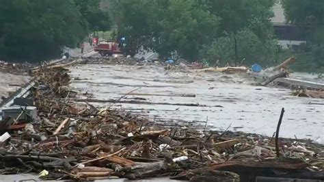
KERRVILLE, Texas — A rescue mission already racing against time took a dangerous and avoidable turn on Monday afternoon when a privately operated drone collided midair with a rescue helicopter assisting in the search and recovery operation after devastating flash floods in Kerr County.
The incident, which took place within a federally restricted flight zone, has drawn sharp criticism from county officials and aviation experts alike, all of whom agree on one critical point: this incident was entirely preventable.
Kerr County Flash Flood Rescue Efforts Disrupted by Reckless Drone Operation
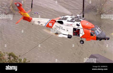
The helicopter, a vital asset in a multi-agency flood response operation, was actively surveying flood-stricken terrain when the collision occurred. According to a statement issued by Kerr County officials, the aircraft was forced to make an emergency landing, prematurely ending its mission and removing a crucial piece of equipment from the disaster response effort.
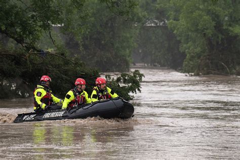
The downed aircraft was part of a coordinated task force composed of local sheriff departments, EMS, fire rescue units, and state emergency management officials. At the time of the collision, the helicopter was engaged in an aerial sweep of rural, waterlogged zones where flash floods had previously swept away structures, livestock, and at least two known victims.
“The drone should never have been in the air,” said a county spokesperson in an official post shared on social media. “When you fly a drone in restricted areas, you’re not just breaking the law — you’re putting first responders, emergency crews, and the public at serious risk.”
Temporary Flight Restriction Ignored: Legal Ramifications Pending
At the time of the incident, a Temporary Flight Restriction (TFR) was clearly in effect. Enforced by the Federal Aviation Administration (FAA), TFRs are implemented during emergency response efforts to ensure airspace is reserved exclusively for official use.
These legal barriers are designed to eliminate the chaos of crowded skies over critical areas, especially when aircraft like helicopters are performing low-altitude, precision-based search patterns. Unauthorized drone operators who violate these zones not only risk federal charges, but also face substantial civil penalties, including fines of up to $30,000 and potential imprisonment.
Authorities have not yet identified the drone operator publicly but confirmed that an investigation is ongoing and that the FAA and Department of Homeland Security are involved.
The Broader Risks of Drones in Emergency Zones
This Kerr County incident isn’t isolated. Across the United States, drone interference in restricted airspace has been an increasing threat to emergency operations — from wildfire containment efforts in California to hurricane rescue missions along the Gulf Coast. Each occurrence disrupts operations, delays assistance, and puts both first responders and the affected public in jeopardy.
In aviation, altitude separation and visual line of sight are paramount. Helicopters typically fly at lower altitudes in disaster zones to scan terrain, drop aid, or perform hoist rescues. Drones, often flown recreationally or for unauthorized documentation purposes, operate within the same vertical space, creating a deadly collision hazard.
“Imagine trying to perform a life-or-death hoist rescue and suddenly a drone appears in your flight path,” said a veteran Texas emergency helicopter pilot. “The propeller impact alone can bring us down.”
Grounding Drones: A Plea from Emergency Officials
In the aftermath of the Kerr County collision, emergency management teams have renewed calls for the public to exercise strict drone discipline during active disaster declarations. Officials are pleading with the community to keep all private drones grounded until the completion of search and rescue efforts.
This appeal is more than just a legal warning; it’s a matter of safety, coordination, and human lives. A drone flight that lasts only minutes can derail multi-hour coordinated efforts involving dozens of people on the ground and in the air.
Search Efforts Delayed, But Ongoing
Despite the setback, Kerr County officials confirmed that search and recovery efforts continued later that evening with limited aerial capacity. Additional helicopters were dispatched from neighboring jurisdictions, but coordination became more difficult due to the gap in coverage and operational planning caused by the forced landing.
The Kerrville Fire Department, one of the primary responding agencies, noted that the loss of the helicopter not only reduced visibility in remote flood-damaged regions but also impacted the transport of critical supplies and aerial support for ground teams navigating unstable terrain.
“This was not a minor inconvenience,” one official stated. “We had to reassign resources, delay ground entries, and reevaluate safety protocols — all because of one reckless decision.”
Technological Tensions: Drones vs. Disaster Relief
While drones have long been hailed as transformative tools in various sectors — agriculture, cinematography, infrastructure inspection — their unregulated presence in emergency zones remains a growing liability. The very capabilities that make them valuable (portability, high-resolution imaging, real-time data capture) also make them dangerously easy to misuse.
In areas like Kerr County, where terrain can be deceptive and weather changes rapidly, drone misuse can turn already dangerous conditions into catastrophic failures of coordination.
Moreover, the proliferation of drone technology has outpaced the rate at which public education and enforcement have kept up. While licensed commercial operators are subject to FAA Part 107 regulations, thousands of hobbyists operate without understanding — or adhering to — airspace restrictions.
FAA and Law Enforcement: A Race to Adapt
In response to rising incidents, the FAA has rolled out new rules mandating remote identification (Remote ID) for most drones, which functions like a digital license plate. But widespread compliance remains elusive, especially among casual users unaware of the legal framework.
Local law enforcement agencies in rural counties like Kerr often lack the resources to track unauthorized drone usage in real-time. The result is a reactive approach to violations, where accountability only follows the damage.
According to a recent FAA enforcement report, there were more than 2,000 unauthorized drone activity complaints in disaster zones across the U.S. in 2024 alone. While some were benign, dozens involved close calls or confirmed collisions with manned aircraft, particularly helicopters involved in firefighting and emergency response.
Community Responsibility: Prevention Through Awareness
Ultimately, incidents like the Kerr County collision highlight a fundamental truth: prevention starts with public awareness. No amount of federal regulation or county-level policy can match the power of an informed, cooperative public.
Emergency officials urge drone owners to:
- Check the FAA’s B4UFLY app before launching any flight.
- Respect Temporary Flight Restrictions during natural disasters.
- Register drones and follow FAA Part 107 guidelines.
- Never fly near emergency scenes, wildfires, or accident zones.
These aren’t just best practices; they’re the difference between aiding recovery and actively endangering lives.
Conclusion: One Drone, One Catastrophe Averted — But At What Cost?
As the Kerr County community continues to recover from historic flooding, the drone collision serves as a harrowing reminder of the fragility of emergency operations. A single drone, improperly deployed, forced an emergency landing, diverted resources, and exposed systemic vulnerabilities in how we manage modern airspace during crises.
Officials are clear: this was not a tragic accident — it was a reckless act that could have been avoided.
In moments of crisis, the air belongs to those risking their lives to save others. Everything else — and everyone else — must get out of the way.


