Most airline passengers assume that every part of the sky is owned and controlled by a nation. After all, aircraft departing New York fly through American airspace, while planes approaching London enter British-controlled skies. Yet during a transatlantic journey, there is a vast portion of the flight where the aircraft is traveling through airspace that belongs to no country at all.
This reality surprises many travelers. The North Atlantic is one of the busiest aviation corridors on Earth, carrying thousands of flights every week between North America and Europe. Despite this immense volume of traffic, no nation possesses sovereignty over most of the airspace above the ocean. Instead, the region operates through an extraordinary system of international cooperation that allows aircraft to move safely across one of the world’s largest stretches of open water.
Understanding how this system works reveals not only the complexity of modern aviation but also the unique legal status of the skies above international waters.
The Difference Between National Airspace and International Airspace
Every sovereign nation controls the airspace above its territory. This principle has been a cornerstone of aviation law for more than a century and is recognized through international agreements, including the Chicago Convention.
A country’s airspace generally extends vertically above its land borders and territorial waters. Over the ocean, sovereignty typically reaches 12 nautical miles (22 kilometers) beyond a nation’s coastline. Within this zone, the country exercises authority over aircraft operations just as it does over activities occurring on the ground.
Once an aircraft flies beyond that 12-nautical-mile boundary, the legal situation changes dramatically.
The skies above the open ocean become international airspace, a region where no nation can claim ownership or sovereignty. Unlike territorial airspace, these areas exist outside national borders and are governed through international aviation agreements rather than domestic law.
For passengers crossing the Atlantic, this means that a significant portion of the flight occurs in airspace that is not legally owned by any country.
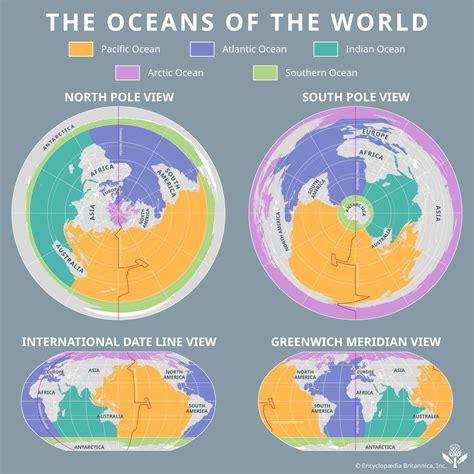
The concept is remarkably similar to international waters. Just as no nation owns the middle of the Atlantic Ocean, no nation owns most of the airspace directly above it.
How the Atlantic Became a Shared Aviation Highway
The growth of long-range aviation during the twentieth century created a unique challenge. Aircraft flying between continents needed air traffic control services, weather information, emergency assistance, and organized routing.
Without some form of coordination, the North Atlantic could easily become chaotic.
The solution was not to divide the ocean into national territories. Instead, the International Civil Aviation Organization (ICAO) established a framework that assigns responsibility for managing specific regions of international airspace.
These regions are known as Flight Information Regions (FIRs).
An FIR is not a territorial claim. Rather, it is an administrative area where a designated country provides air traffic services and flight information.
This distinction is crucial.
A nation may manage air traffic within an FIR stretching hundreds of miles offshore without possessing any sovereign rights over that airspace.
The arrangement represents one of the most successful examples of international cooperation in modern transportation.
What Flight Information Regions Actually Do
Flight Information Regions serve as the organizational backbone of global aviation.
Each FIR is managed by air traffic control facilities responsible for maintaining safe and orderly aircraft operations. Controllers provide routing instructions, weather updates, traffic information, emergency support, and communication services.
Over land, FIRs usually align closely with national boundaries. Over oceans, however, they expand far beyond territorial limits.
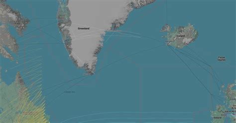
Across the North Atlantic, several major FIRs share responsibility for aircraft movements.
The southern Atlantic region is managed by facilities including New York Oceanic and Santa Maria. Further north, Gander and Shanwick oversee some of the busiest oceanic corridors in the world. Reykjavik manages extensive areas surrounding Iceland and Greenland, while Bodo Oceanic controls large portions of the northeastern Atlantic.
Although these control regions appear on aviation charts as clearly defined sectors, they do not represent ownership. They simply indicate which air traffic organization is responsible for providing services in that area.
This distinction allows international aviation to function efficiently while preserving the principle that international airspace belongs to no nation.
Why Oceanic Air Traffic Control Is Different
Managing aircraft over the ocean presents challenges that do not exist over land.
Traditional radar systems have limitations. Ground-based radar installations cannot effectively track aircraft thousands of miles from shore because the Earth’s curvature blocks the radar signal.
For decades, this meant controllers could not continuously monitor aircraft positions over the middle of the Atlantic.
As a result, oceanic air traffic management developed procedures very different from those used over continents.
Instead of relying entirely on radar surveillance, controllers organized aircraft using structured routes, position reports, and strict separation standards.
Aircraft crossing the Atlantic typically follow designated corridors known as North Atlantic Tracks (NATs). These routes are adjusted twice daily to take advantage of changing winds and jet stream patterns.
The system maximizes efficiency while ensuring that aircraft remain safely separated from one another.
The Famous North Atlantic Tracks
The North Atlantic Track system is among the most sophisticated traffic-management networks ever developed.
Every day, aviation authorities analyze weather conditions across the Atlantic and publish optimized routes connecting North America and Europe.
Aircraft operators select tracks that best match their destinations and performance requirements.
Rather than scattering randomly across the ocean, hundreds of flights follow organized pathways that resemble invisible highways in the sky.
These tracks shift regularly because atmospheric conditions constantly change. Strong west-to-east jet streams can significantly reduce travel times for eastbound flights, while westbound flights often seek routes that minimize headwinds.
The result is a dynamic network that changes daily while maintaining exceptional safety standards.
Virtually every major airline operating between Europe and North America relies on this system.
How Aircraft Stay Separated Without Radar
When passengers look out the window at cruising altitude, they often assume air traffic controllers can see their aircraft on radar at all times.
Historically, that was not the case over the Atlantic.
Because radar coverage was unavailable across much of the ocean, aircraft separation depended on carefully designed procedures.
Controllers maintained safety using three primary forms of separation:
- Vertical separation between aircraft flying at different altitudes.
- Longitudinal separation based on time intervals between aircraft on the same route.
- Lateral separation achieved through designated track structures.
Modern aircraft operating between approximately 29,000 and 41,000 feet can often be separated vertically by 1,000 feet. Longitudinally, aircraft are generally spaced by several minutes along the same track.
These procedures have allowed millions of ocean crossings to occur safely despite the absence of traditional radar coverage across large portions of the Atlantic.

The Technology That Connects Aircraft Across Oceans
Communication has always been one of the biggest challenges in oceanic aviation.
For much of aviation history, pilots crossing oceans relied on High Frequency (HF) radio systems.
HF radio signals can travel enormous distances by reflecting off layers of the atmosphere. Using this technology, pilots communicated with radio operators who relayed messages to air traffic controllers.
The process worked, but it was often slow and susceptible to atmospheric interference.
Today, satellite technology has transformed oceanic communications.
The most important advancement is Controller-Pilot Data Link Communications (CPDLC). This system functions much like a secure text messaging platform connecting pilots directly with controllers.
Instead of reading lengthy instructions over radio frequencies, crews can receive digital messages and respond electronically.
Modern aircraft also use Automatic Dependent Surveillance–Contract (ADS-C) systems, which automatically transmit position information through satellite networks.
Together, CPDLC and ADS-C have dramatically improved situational awareness across oceanic regions.
Controllers now have access to far more accurate and timely position data than was possible during the era of purely voice-based reporting.
Satellite Surveillance Changed Everything
The arrival of satellite-based tracking revolutionized oceanic air traffic management.
Aircraft can now transmit detailed position reports directly to air traffic control centers, reducing uncertainty and improving operational efficiency.
Although separation standards over oceans remain more conservative than those used in radar-controlled continental airspace, controllers can monitor aircraft movements with a level of precision that would have seemed impossible only a few decades ago.
Satellite surveillance has also enhanced safety by improving search-and-rescue capabilities and enabling quicker responses to emergencies.
Events such as aircraft diversions, medical emergencies, and severe weather encounters can be managed far more effectively than in the past.
The modern North Atlantic airspace system combines traditional procedural control with advanced digital technologies, creating one of the safest transportation environments on Earth.
The Invisible Ceiling of National Airspace
While the Atlantic raises questions about horizontal boundaries, another fascinating issue involves the vertical limits of sovereignty.
At what altitude does national airspace end?
Surprisingly, international law provides no universally accepted answer.
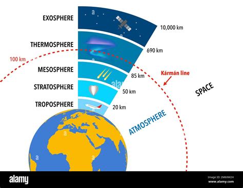
The most widely recognized reference point is the Kármán Line, located approximately 100 kilometers (62 miles) above sea level.
Named after aerospace engineer Theodore von Kármán, this altitude represents the point where the atmosphere becomes too thin for conventional aircraft wings to generate sufficient aerodynamic lift.
Beyond this level, vehicles must essentially operate as spacecraft rather than airplanes.
Many organizations use the Kármán Line as the symbolic boundary between Earth’s atmosphere and outer space.
Yet it remains more of a guideline than a legally binding border.
Why the Kármán Line Is Still Debated
Despite its widespread recognition, the Kármán Line is not officially adopted by international treaties.
The Chicago Convention never established a definitive altitude where sovereign airspace ends and outer space begins.
As a result, different countries apply different interpretations.
The United States, for example, often recognizes space as beginning at 50 miles (80 kilometers) rather than 62 miles.
This discrepancy affects how governments classify astronauts, spacecraft missions, and experimental aerospace vehicles.
The challenge arises because Earth’s atmosphere does not end abruptly. Instead, it gradually becomes thinner with increasing altitude.
Solar activity, atmospheric density, and environmental conditions can all influence where a practical transition between air and space occurs.
From a scientific perspective, no perfectly precise boundary exists.
From a legal perspective, however, governments eventually need one.
Why Space Is Different From Airspace
Unlike national airspace, outer space operates under a fundamentally different legal framework.
International treaties establish space as a global commons that cannot be claimed by any nation.
No country can declare ownership of the Moon, Mars, or orbital regions surrounding Earth.
This principle mirrors the status of international airspace above the oceans.
However, uncertainty remains regarding the exact altitude where national sovereignty gives way to international space law.
As commercial space tourism expands and hypersonic vehicles become more common, these questions are becoming increasingly important.
Companies such as Virgin Galactic and Blue Origin routinely operate near the disputed boundary region, highlighting the practical implications of defining where space truly begins.
The Remarkable Cooperation Behind Every Atlantic Crossing
The average passenger crossing the Atlantic rarely notices the immense international effort required to make the journey possible.
An aircraft may depart from one country’s airspace, enter international airspace managed by multiple foreign control centers, cross several Flight Information Regions, communicate through satellite systems, and finally arrive in another nation’s sovereign skies.
Throughout the process, no country owns the majority of the airspace being traversed.
Instead, safety depends on shared standards, coordinated procedures, advanced technology, and mutual trust among nations.
The North Atlantic remains one of humanity’s greatest examples of peaceful international cooperation. Thousands of aircraft move across a region belonging to no state, guided not by ownership but by collective responsibility.
Every transatlantic flight is therefore more than a journey between continents. It is a demonstration of how countries can work together to manage a global commons—an immense expanse of sky above the ocean where sovereignty ends, cooperation begins, and no nation on Earth owns the air through which millions of travelers safely pass each year.


